|
|
Glen Canyon Dam Long-Term Experimental and Management Plan EIS
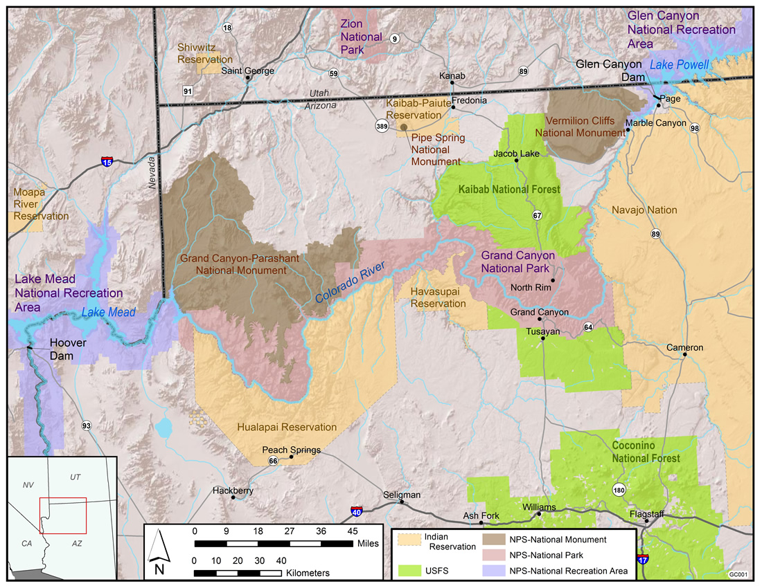
What Is in the LTEMP FEIS?The LTEMP FEIS evaluates the impacts of a long-term experimental and management plan for operations of Glen Canyon Dam on resources in and along the Colorado River. The LTEMP FEIS analyzes the potential environmental impacts of alternative operating protocols and other management actions to protect downstream resources for future generations, conserve species listed under the Endangered Species Act, avoid or mitigate impacts on National Register of Historic Places (NRHP)-eligible properties, and protect the interests of American Indian Tribes, while meeting obligations for water delivery and the generation of hydroelectric power. What is the geographic scope of the analysis in the FEIS?The geographic scope of the LTEMP FEIS analysis is the area affected by Glen Canyon Dam operations and other components of the LTEMP. In general, the region examined in this FEIS includes the area potentially affected by implementation of the LTEMP (normal and experimental operations of Glen Canyon Dam and non-flow actions). This area includes Lake Powell, Glen Canyon Dam, and the river downstream to Lake Mead. More specifically, the scope primarily includes the Colorado River Ecosystem, which includes the Colorado River mainstream corridor and interacting resources in associated riparian and terrace zones, located primarily from the forebay of Glen Canyon Dam to the western boundary of Grand Canyon National Park (GCNP). It includes the area where dam operations impact physical, biological, recreational, cultural, and other resources. Portions of Glen Canyon National Recreation Area (GCNRA), GCNP, and Lake Mead National Recreation Area (LMNRA) are included within this area. For certain resources, such as socioeconomics, air quality, and hydropower, the affected region is larger and includes areas potentially affected by indirect impacts of the LTEMP. The potentially affected regions for these resources are specifically identified in Chapters 3 and 4 of the FEIS.
What alternatives were analyzed in the LTEMP FEIS?The FEIS assesses the potential environmental effects of seven alternatives: the No-Action Alternative (Alternative A) and six action alternatives (Alternatives B, C, D, E, F, and G). These alternatives are described in the Notice of Availability (NOA) and the Description of Alternatives (Chapter 2) in the FEIS. What impacts and issues were addressed in the LTEMP FEIS?The LTEMP FEIS analyzes impacts on those resources that could be affected by operations of Glen Canyon Dam and other components of the LTEMP. Direct, indirect, and cumulative impacts of the effects of the proposed action, in combination with the effects of past, present, and reasonably foreseeable future projects, were analyzed in the LTEMP EIS for the following impact topics:
|
|||||||||||||||||||||
|
| ||||||||||||||||||||||